
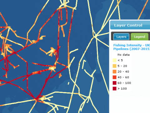
Fishing Intensity - UK Fishing Intensity Associated with Oil and Gas Pipelines (2007-2015) – (All Gears; Demersal Trawls; Dredges; Nephrops Trawls)
What is it:
The four layers provide information on the intensity of mobile fishing associated with oil and gas pipelines and cables.
- Fishing Intensity - UK Fishing Intensity Associated with Oil and Gas Pipelines (2007-2015) - All Gears
- Fishing Intensity - UK Fishing Intensity Associated with Oil and Gas Pipelines (2007-2015) - Demersal Trawls
- Fishing Intensity - UK Fishing Intensity Associated with Oil and Gas Pipelines (2007-2015) – Dredges
- Fishing Intensity - UK Fishing Intensity Associated with Oil and Gas Pipelines (2007-2015) - Nephrops Trawls
Each layer was created by calculating the total number of fishing tracks in 1 km by 1 km squares along the length of each pipeline for four gear categories (see More Information below). Fishing tracks were recreated for UK vessels greater than 15 m in length between 2007-2015 operating mobile demersal gear (otter trawls, pair trawls, beam trawlers and dredges – see link in ‘Additional Information’ tab below) using vessel position data extracted from the Vessel Monitoring System.
The legend shows the total number of fishing tracks from UK vessels in 1 km by 1 km squares along the length of each pipeline according to year.
Links to Scotland's Marine Atlas:
Data originators:
This information page is part of the theme:
Fishing Intensity - UK Fishing Intensity Associated with Oil and Gas Pipelines (2007-2015) - All Gears © Marine Scotland