The Moray Firth
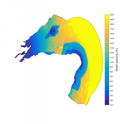
The Moray Firth (MF) is the largest firth in Scotland and is regularly visited by marine wild life and the area includes a special area of conservation (SAC), proposed Marine Protected Area (MPA) and several Special Protection Areas (SPA). In addition, the Moray Firth is a host of multiple wind warm sites, specifically in the Smith Bank area. The MF model is an implementation of the Finite Volume Community Ocean Model (FVCOM) and has a domain covering the Cromarty Firth, the Dornoch Firth, the Moray coast as well as the coast from Fraserburgh to Aberdeen. The domain extends from approximately 1° - 4.5° W and 56.5° - 58.5° N. The model grid is unstructured with the highest horizontal resolution in the Cromarty and Dornoch Firth as well as the Smith Bank area. The node spacing varies from less than 50 m to approximately 3 km along part of the outer boundary however in the finer resolution areas the resolution is typically around 100 - 200 m. The vertical water column is resolved using 10 terrain following sigma layers, each representing 10 % of the water column.
This model is currently under development. Any available model outputs will be listed here.