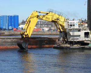
Dredge spoil deposit
What is it:
Locations of dredge spoil deposit sites indicated by points (beyond 1:2,000,000) and polygons (below 1:2,000,000).
The spoil is usually as a result of navigational dredging (deepening of navigation channels) on the approaches to ports and harbours.
These sites are designated as open (in use), disused (not used for at least 5 years) or closed (not used for at least 10 years or specifically closed).
Dredge spoil deposit is licensed by Marine Scotland who also monitor the sites.
Updated graphs (as found in Scotland’s Marine Atlas) can be accessed in the ‘Data Sources’ tab at the bottom of the page.
Date of Data: 2015
Links to Scotland's Marine Atlas:
Data originators:
This information page is part of the theme:

Plough Dredger at Aberdeen Harbour - Copyright © Marine Scotland
Links and Resources
| Type |
Link Title |
External Link |
|---|---|---|
| Tabular Data | Waste Disposal (Dredge Spoil) (2013-2018) |

