
Sections
Key message

What, why and where?
Marine aggregate extraction removes sand and gravel from the seabed for use as construction aggregate (in concrete), land reclamation (as fill) or beach replenishment. Although Scotland has considerable marine sand and gravel resource, historically the marine aggregate industry has been very small because land supplies are more readily accessible. In some cases, marine transportation is essential for land based extraction due to its distribution and viability.
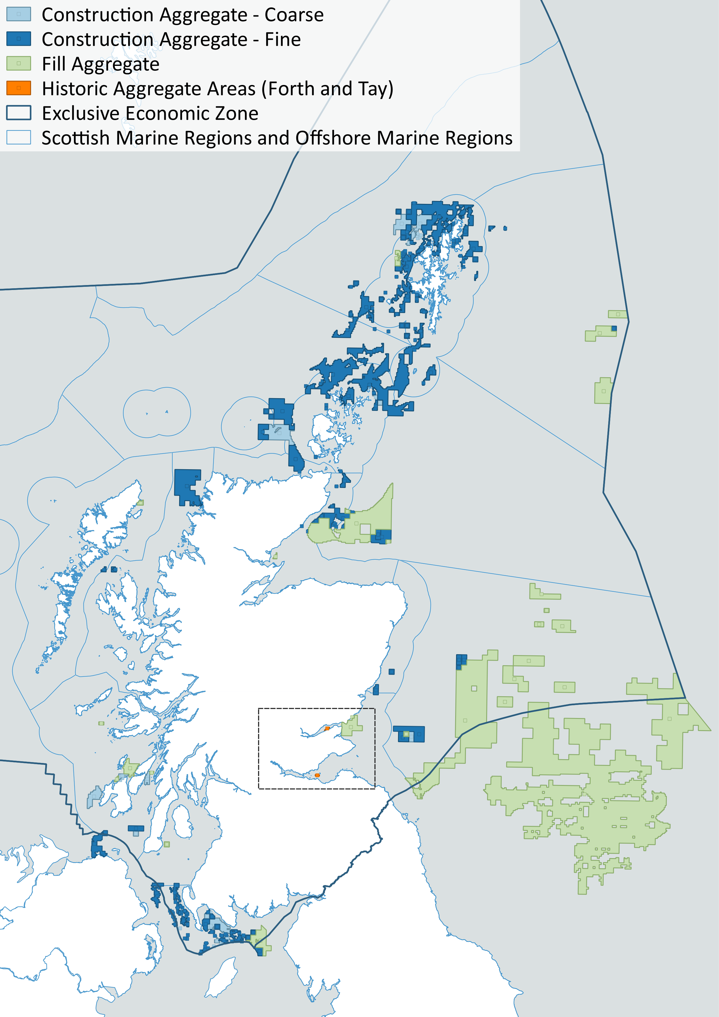
There are no areas currently licensed for marine aggregate extraction. In recent times, marine aggregate was extracted from two sites: one in the Firth of Forth (last dredged in 2005) and one in the Firth of Tay (last dredged several years before that). Both sites are in the Forth and Tay Marine Region (Baxter et al., 2008) (Figure 1).
A recent example of beneficial use of aggregates, is the south harbour expansion in Aberdeen (February 2017 – expected completion February 2020 http://marine.gov.scot/ml/aberdeen-harbour-expansion), where dredged material is re-used in the harbour construction.
An assessment undertaken by the British Geological Survey on behalf of the Crown Estate (BGS, 2013) identified marine sand and gravel deposits in Scottish waters (see figure 2). Potential mineral resource has also been inferred from geological data but has not yet been evaluated.
Aggregate extraction is subject to licensing procedures, under section 21 of the Marine (Scotland) Act 2010 which considers, amongst other things, environmental impact. An application would require screening under The Marine Works (Environmental Impact Assessment) (Amendment) Regulations 2017. An agreement to dredge the seabed is also required from Crown Estate Scotland as seabed owner.

Contribution to the economy
Any extraction would contribute to the economy through the provision of raw material for use in the construction industry. While no marine aggregate dredging has been carried out in recent years, Scotland’s Annual Business Survey reported that ‘Other Mining and Quarrying’ contributed £301 million to Scotland’s economy in 2017 and employed over 2,000 people. The category includes extraction from a mine or quarry, but also dredging of alluvial deposits, rock crushing and the use of salt marshes.
While there has been no recent aggregate extraction from the sea, the land based Glensanda Quarry on the Morvern peninsula contributes significantly to the Scottish economy, with an annual production of about 6 M tonnes of aggregate (Transport Scotland, 2018). With access only via sea, it relies entirely on Glensanda port, for transportation of aggregate, supplies and personnel, making Glensanda one of the top 11 ports in Scotland.
Examples of socio-economic effects
Current impacts on Scotland’s socio-economic do not exist. In the event of extraction there is the possibility of:
-
Employment.
-
Generation of income through the construction industry supply chain.
-
Provision of raw material for construction or to replenish beaches.
-
Impact on or the displacement of other users of the sea.
-
Potential conflict in competition for sea space.
Pressures on the environment
An OSPAR agreed list of marine pressures is used to help assessments of human activities in the marine environment. The marine pressure list has been adapted for use in Scotland via work on the Feature Activity Sensitivity Tool (FeAST). Aggregate extraction activities can be associated with 21 marine pressures – please read the pressure descriptions and benchmarks for further detail.
The list of marine pressures is used to help standardise assessments of activities on the marine environment, and is adapted from an agreed list prepared by OSPAR Intercessional Correspondence Group on Cumulative Effects (ICG-C) (see OSPAR 2014-02 ‘OSPAR Joint Assessment and Monitoring Programme (JAMP) 2014-2021’ Update 2018’ (Table II).
The Feature Activity Sensitivity Tool (FeAST) uses the marine pressure list to allow users to investigate the sensitivity of Scottish marine features. It also associates all pressures that might be exerted by a defined list of activities at a particular benchmark. The extent and impact of each pressure from a given activity will vary according to its intensity or frequency. The extent and impact of the pressure will also vary depending on the sensitivity of the habitat or species on which it is acting. The existence of multiple activities, and potentially multiple pressures, at specific locations will result in a cumulative impact on the environment.
FeAST is a developing tool. A snap shot from 2019 was used for the development of SMA2020. Please consult the FeAST webpage for further information and up to date information.
The list of pressures below associated with this activity is given in alphabetical order. Clicking the pressure will give you more information on the pressure and examples of how it may be associated with the activity.
Forward look
Potential commercially viable deposits of marine sand and gravel are present in Scottish waters. Work for the Crown Estate (BGS, 2013) provides sand, gravel and mineral resource maps for Scotland which are designed to help visualise how aggregates and minerals are distributed off the coast. However, potential mineral resources remain inferred from the nature of the seabed geology and have not yet been evaluated by detailed survey. While there is little short-term demand for these resources, medium to long-term future market demands and technological advances will influence their viability and strategic importance.
If extraction becomes viable under different economic conditions or if increased dredging capability (in terms of ability to dredge in deeper water depths) offers opportunity for extraction in new areas, the potential could be exploited. Any future extraction would be subject to a marine licence as well as being screened under The Marine Works (Environmental Impact Assessment) (Amendment) Regulations 2017. Possible future use of marine aggregates includes use in gravity bases for the renewables industry and in coastal defence and adaptation schemes.
Economic trend assessment
There are no working aggregates sites in Scottish waters. As such there are no trends to report.
This Legend block contains the key for the status and trend assessment, the confidence assessment and the assessment regions (SMRs and OMRs or other regions used). More information on the various regions used in SMA2020 is available on the Assessment processes and methods page.
Status and trend assessment
|
Status assessment
(for Clean and safe, Healthy and biologically diverse assessments)
|
Trend assessment
(for Clean and safe, Healthy and biologically diverse and Productive assessments)
|
||
|---|---|---|---|
 |
Many concerns |
No / little change |
|
 |
Some concerns |
Increasing |
|
 |
Few or no concerns |
Decreasing |
|
 |
Few or no concerns, but some local concerns |
No trend discernible |
|
 |
Few or no concerns, but many local concerns |
All trends | |
 |
Some concerns, but many local concerns |
||
 |
Lack of evidence / robust assessment criteria |
||
| Lack of regional evidence / robust assessment criteria, but no or few concerns for some local areas | |||
 |
Lack of regional evidence / robust assessment criteria, but some concerns for some local areas | ||
| Lack of regional evidence / robust assessment criteria, but many concerns for some local areas | |||
Confidence assessment
|
Symbol |
Confidence rating |
|---|---|
|
Low |
|
|
Medium |
|
|
High |

Assessment regions
 and the Scottish Offshore Marine Regions (OMRs, O1 – O10)")
Key: S1, Forth and Tay; S2, North East; S3, Moray Firth; S4 Orkney Islands, S5, Shetland Isles; S6, North Coast; S7, West Highlands; S8, Outer Hebrides; S9, Argyll; S10, Clyde; S11, Solway; O1, Long Forties, O2, Fladen and Moray Firth Offshore; O3, East Shetland Shelf; O4, North and West Shetland Shelf; O5, Faroe-Shetland Channel; O6, North Scotland Shelf; O7, Hebrides Shelf; O8, Bailey; O9, Rockall; O10, Hatton.
 Regions. These have been used as the assessment areas for hazardous substances.")
, Regions.")