
What, why and where?
There is a significant seaweed resource (Scottish Government, 2016), particularly abundant in three geographical areas: west of the Outer Hebrides, the Minch and Inner Hebrides and the north coast of Orkney.
Scotland’s main commercial wild seaweed harvesting is based in the Outer Hebrides and is focussed on egg or knotted wrack (Table 1). Overall, the wild seaweed harvesting industry is small-scale, harvesting a range of brown (wracks or kelp), red and green seaweeds. The maps in Figure 1 show the known current and potential seaweed resource areas by type of seaweed.
Most harvesting involves hand cutting with limited gathering of beach-cast seaweed. Mechanical cutting of egg or knotted wrack takes place in Lewis and Harris. The main species harvested in biomass terms is egg or knotted wrack. Other species hand harvested, in smaller volumes, include: kelps, other wrack species, carragheens (Mastocarpus stellatus and Chondrus crispus), dulse (Palmaria palmata), pepper dulse (Osmundea spp.) and laver (Porphyra spp.).
 Wracks")
 Green seaweed")
 Kelp")
 Red seaweed")
Figure 1: Seaweed resource areas from 2016 Strategic Environmental Assessment (SEA) of wild seaweed harvesting.


Seaweed is utilised throughout the world as a source of food, animal feed and fertiliser as well as being used in a wide range of industries such as cosmetics, nutraceuticals and pharmaceuticals. There is growing commercial interest in Scotland in the seaweed resource as properties of various species and potential uses in various products are being recognised. The Scottish Government is building its evidence base, and commenced a seaweed review in 2019 to gather evidence on the sustainability of current and future seaweed harvesting activity and consider opportunities to grow the wider sector. It is also considering the environmental implications of seaweed removal by any method. Progress of this review is reported here.
Seaweed cultivation takes place either through the growing of a single species or alongside fin fish and shellfish farming.
|
SMR
|
Location
|
Species
|
Volume
|
Frequency of harvest
|
Harvest method
|
|
Solway
|
Luce Bay, Wigtonshire
|
Unknown
|
About 40 tonnes per annum
|
Assumed year round
|
Hand harvesting/gathering of cast weed
|
|
Clyde
|
Hunterston Power station
|
Various species
|
300 wet tonnes (most recent application)
|
Annual
|
Removal using a vessel for operational reasons
|
|
Argyll
|
Firth of Lorn; Argyll islands including Luing and the Garvellachs
|
9 species
|
9 tonnes (1 of each) per year
|
All year round
|
Hand harvesting, including from a boat
|
|
West Highlands
|
Skye
|
Range of intertidal species
|
5-6 wet tonnes
|
All year round
|
Hand
|
|
Summer Isles
|
3 intertidal species
|
100 kg of 3 species
|
All year round
|
Hand
|
|
|
Ardnamurchan
|
Few intertidal species
|
Unspecified small amount (range: tens of kilos)
|
-
|
Hand
|
|
|
Outer Hebrides
|
Lewis and Harris
|
Ascophyllum
|
Up to 11,500 wet tonnes per annum on CES foreshore
Additional tonnage on private, community land unknown
|
Year round, weather and tides permitting
|
Hand and mechanical using modified boat with cutter.
|
|
North Uist
|
Ascophyllum
|
Thought to be in the region of 2,100 wet tonnes (2018) but projected to have increased significantly
|
Year round, weather and tides permitting
|
Hand and manual from boat using a rake.
|
|
|
North Uist
|
H. elongata
|
9 wet tonnes
|
April to October
|
Hand from a boat.
|
|
|
North Coast / Moray Firth
|
Caithness (east of Thurso and south towards Wick)
|
No species determined
|
Total quota is thousands wet tonnes per annum (based on 20% total shore biomass). Current level (2019) is less than 100 wet tonnes
|
All year round
|
Hand harvesting
|
|
Orkney Islands
|
Sanday, Orkney
|
11 species
|
Less than 1 wet tonne per annum
|
All year round
|
Hand harvesting
|
|
Forth and Tay
|
Fife coast
|
P. Palmata
|
305 wet tonnes
|
P. palmata growing season (May-Oct)
|
Hand harvesting, possibly using a boat
|
|
Fife Coast
|
P. Palmata
|
100 wet tonnes
|
P. palmata growing season (May-Oct)
|
Hand harvesting
|
|
|
Longniddry to Yelowcraigs, East Lothian
|
8 species including 3 kelps
|
Less than 1 tonne in total
|
All year round
|
Hand harvesting
|
Methods of seaweed harvesting
Commercial harvest of wild seaweeds is currently undertaken by one of three methods: hand cutting, hand gathering and mechanical harvesting. Hand cutting and gathering can also include baling of the seaweed to be towed by boat and also the use of boat to rake seaweed.
- Hand cutting involves the removal of part or all of living seaweed from its position of growth on the foreshore or seabed by hand by any means. Removal by hand may involve the use of scissors, scythes, knives or rakes.
- Gathering is the collection of any seaweed no longer in the position of growth. This typically refers to beach cast or drift seaweed, deposited on the shore by the tide.
- Mechanical gathering involves the collection of beach-cast plants from the strandline using tractors or mechanical diggers. This is not thought to be currently undertaken in Scotland other than for environmental or beach cleaning reasons (use of vehicles to remove litter or seaweed from beaches can be subject to a marine licence exemption).
- Mechanical cutting involves the use of specialised vessels / modified boats that work close to the shore and cut or “mow” the floating seaweed stalks above the seabed. In Scotland, this method is principally used to harvest egg or knotted wrack (Ascophyllum nodosum) by cutting above the meristem so that the plant can grow back. Mowing of kelp species is undertaken in other countries which brings the risk of killing the plant if the mow cuts below the meristem / growing point.
- Mechanical trawling / sledging / dredging involves a device which tears plants from the substrate. The use of a vessel to remove seaweed from the sea bed is a ‘licensable marine activity’ under the Marine (Scotland) Act. To date, no marine licences have been granted in Scotland for the harvesting of kelp in this way*. In the case of kelp, commercial harvesting in this way, which kills the plant, is prohibited under section 15 of Scottish Crown Estate Act 2019.
* marine licences have been issued to remove kelp from around power station water intakes.
|
Species name
|
Generic methods of harvesting
|
|
Brown seaweeds
|
|
|
Wracks
|
|
|
Egg or knotted wrack
(Ascophyllum nodosum)
(intertidal) (Figure a)
|
Harvesting takes place all year round and the cutting is carried out either manually using a knife/sickle or mechanically using a seaweed harvesting boat. Harvest may also involve the use of boat and rake. Traditionally, harvesters encircle a chosen cutting area with a rope or net and will then cut within this area. The seaweed is cut about 12 inches from the base and the stump that is left will then regenerate in 3 to 4 years. The floating cut seaweed tis bound into a circular bale and towed by a small boat to a sheltered area for loading onto a lorry. Individual cutters handle their own cutting areas and rotate the areas cut to ensure sustainability
A mechanical seaweed harvester may also be used. This vessel works close to the shore and cuts the seaweed as the stalks float above the seabed. The seaweed is loaded onto small boats and transferred to a sheltered area for loading onto a lorry
Recovery of growing seaweed varies according to harvesting method, frequency of cutting and time of year. Also on the height of the mechanical cutter is set to above the seabed relative to tidal state. Hand harvesting generally takes longer to regenerate requiring a longer period before returning to harvest the same area again
|
|
Pelvetia canaliculata (intertidal)
Common name/s: Channelled wrack
|
Typically harvested by hand at low tide with knives, scissors or scythes, cutting above the holdfast to allow regrowth
|
|
Fucus vesiculosus (intertidal)
Common name/s: Bladder wrack
|
Typically hand harvested at low tide with knives, scissors or scythes, cutting above the holdfast to allow regrowth
|
|
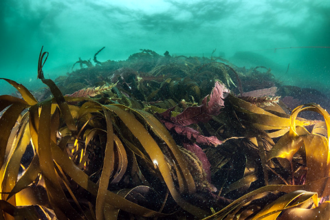
Fucus serratus (intertidal) (Figure b)
Common name/s: Saw wrack or Toothed wrack
|
Typically harvested by hand at low tide with knives, scissors or scythes, cutting above the holdfast to allow regrowth
|
|
Fucus spiralis (intertidal)
Common name/s: Spiral wrack
|
Typically harvested by hand at low tide with knives, scissors or scythes, cutting above the holdfast to allow regrowth
|
|
Himanthalia elongata (intertidal)
Common name/s: Sea thong
|
Gathered by hand during May and June, and the fronds are cut at least 10 cm from the mushroom-like base
|
|
Kelps (Figures c and d)
|
|
|
Saccharina latissima (subtidal)
Common name/s: Sugar kelp,
|
Hand harvested by wading, diving or cutting from a small boat at low tide using knives, scissors or scythes. Plants are cut above the meristem (growth point) to allow regrowth
|
|
Laminaria hyperborea (subtidal)
Common name/s: tangle or cuvie
|
Hand harvested by wading, diving or cutting from a small boat at low tide using knives, scissors or scythes. Plants are cut above the meristem (growth point) to allow regrowth. In Scotland, some beach-cast L. hyperborea is gathered
|
|
Laminaria digitata (inter/subtidal)
Common name/s: oarweed
|
Hand harvested by wading, diving or cutting from a small boat at low tide using knives, scissors or scythes. Plants are cut above the meristem (growth point) to allow regrowth
|
|
Alaria esculenta (inter/subtidal)
Common name/s: Dabberlocks
|
Hand harvested by wading, diving or cutting from a small boat at low tide using knives, scissors or scythes. Plants are cut above the meristem (growth point) to allow regrowth
|
|
Green seaweeds
|
|
|
Ulva intestinalis and Ulva lactuca (intertidal)
Common name/s: Sea-lettuce
|
Typically harvested by hand at low tide with knives, scissors or scythes, cutting above the holdfast to allow regrowth
|
|
Red seaweeds
|
|
|
Chondrus crispus (intertidal)
Common name/s: Carragheens, Irish moss or Carrageen moss
|
Typically harvested by hand at low tide with knives, scissors or scythes, cutting above the holdfast to allow regrowth
|
|
Mastocarpus stellatus (intertidal)
Common name/s: Carragheens, Clúimhin Cait, False Irish moss
|
Typically harvested by hand at low tide with knives, scissors or scythes, cutting above the holdfast to allow regrowth
|
|
Palmaria palmata (intertidal)
Common name/s: Dulse
|
Typically harvested by hand at low tide with knives, scissors or scythes, cutting above the holdfast to allow regrowth
|
|
Osmundea pinnatifida (intertidal)
Common name/s: Pepper dulse
|
Harvested at low tide by hand with scissors or a blade above the holdfast to allow regrowth
|
|
Porphyra umbilicalis (intertidal)
Common name/s: Purple laver
|
Harvested at low tide by hand with scissors or a blade above the holdfast to allow regrowth
|
|
Porphyra purpurea (intertidal)
|
Harvested at low tide by hand with scissors or a blade above the holdfast to allow regrowth
|
Seaweed, particularly kelp and the role kelp beds play in supporting marine biodiversity, provide vital habitat and protection for many fish and shellfish species. They also provide a number of ecosystem services (see Natural capital, ecosystem services and the Blue Economy section), including natural hazard protection and climate regulation.
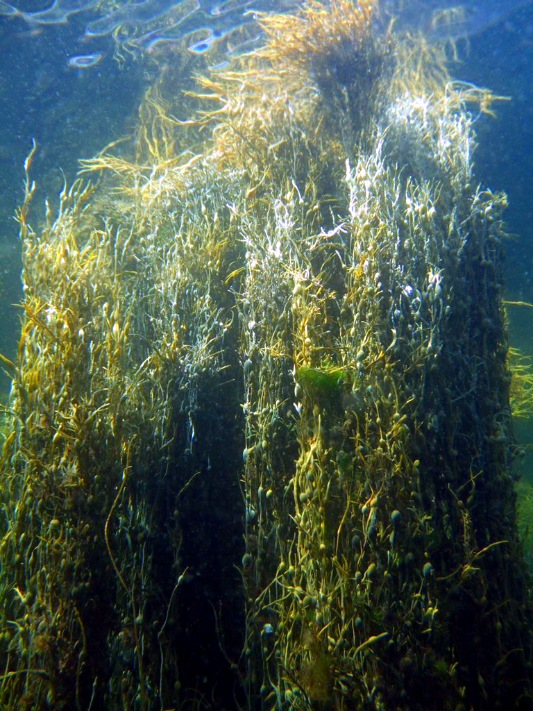
Figure a: Ascophyllum underwater © NatureScot.


A Scottish Government review is underway to gather evidence on the environmental implications of seaweed removal by any method and to consider the sustainable development of the seaweed sector. Progress of this review is reported here.
Seaweed cultivation
Seaweed cultivation is a growing area of interest. This takes place either through the cultivation of a single species or as part of Integrated Multi-Trophic Aquaculture (IMTA) development. IMTA is where seaweed, whose culture relies on nutrient or energy extraction, takes place alongside, for example, fin fish farming where species are fed. Seaweeds in such integrated cultivation systems function as extractive components within a cultivation food web. In addition to reducing the environmental impact of intensive fish aquaculture, IMTA systems add value to the investment in finfish aquaculture by increasing the yield of total biomass produced on a single site (Barrington, Chopin & Robinson, 2009).
Integrated Multi-Trophic Aquaculture – a trial
In conventional salmon farming, around 60% of the nitrogen in the salmon feed is lost to the wider loch ecosystem and can have negative ecological impacts if present in high concentrations. Making use of the waste as a resource is at the heart of the IMTA approach. In the IMTA trial (Loch Fyne), seaweed and shellfish are grown close to the salmon in order to maximise uptake of the nutrients. The shellfish benefit from the organic particulates and the seaweed from the soluble nutrients, including nitrogen. The trial also includes growing sea urchins on some of the seaweed.
A range of shellfish has been used in the Scottish Salmon Company trial including: mussels, oysters and queen scallops, each of which has established markets, as well as sea urchins which are less established. The main seaweed species being grown in the trials is edible kelp (Zero Waste Scotland, 2019).
Contribution to the economy
Currently, with seaweed harvesting and cultivation mostly occurring as small scale activities in Scotland, no information is available on its economic contribution. The total volume of seaweed harvested is recorded to be around 15,000 tonnes. However, this activity is not spread evenly throughout Scotland and is concentrated in the Outer Hebrides, where around 13,600 tonnes are harvested.
However, as part of The Scottish Government’s wider seaweed review, research is underway focusing on understanding the potential scale and type of seaweed-based industries that may be established in Scotland. It is also investigating emerging market opportunities for various seaweed based products, including their associated wider socioeconomic impacts. Key deliverables are expected to cover:
- The potential scope (e.g. by product type), scale (volumes, turnover, Gross Value Added (GVA) and employment) and location of seaweed based industries that may establish in Scotland.
- How the supply chain for various seaweed industries may develop.
- The wider socioeconomic consequences on other industries and communities that may arise from both the direct and indirect impacts from local seaweed-based industries.
Progress of this work is reported here.
Examples of socio-economic effects
- Employment
- Natural product for local economy
- Potential conflict with other sea users
Pressures on the environment
An OSPAR agreed list of marine pressures is used to help assessments of human activities in the marine environment. The marine pressure list has been adapted for use in Scotland via work on the Feature Activity Sensitivity Tool (FeAST). Seaweed harvesting & cultivation activities can be associated with 24 marine pressures – please read the pressure descriptions and benchmarks for further detail.
The list of marine pressures is used to help standardise assessments of activities on the marine environment, and is adapted from an agreed list prepared by OSPAR Intercessional Correspondence Group on Cumulative Effects (ICG-C) (see OSPAR 2014-02 ‘OSPAR Joint Assessment and Monitoring Programme (JAMP) 2014-2021’ Update 2018’ (Table II).
The Feature Activity Sensitivity Tool (FeAST) uses the marine pressure list to allow users to investigate the sensitivity of Scottish marine features. It also associates all pressures that might be exerted by a defined list of activities at a particular benchmark. The extent and impact of each pressure from a given activity will vary according to its intensity or frequency. The extent and impact of the pressure will also vary depending on the sensitivity of the habitat or species on which it is acting. The existence of multiple activities, and potentially multiple pressures, at specific locations will result in a cumulative impact on the environment.
FeAST is a developing tool. A snap shot from 2019 was used for the development of SMA2020. Please consult the FeAST webpage for further information and up to date information.
The list of pressures below associated with this activity is given in alphabetical order. Clicking the pressure will give you more information on the pressure and examples of how it may be associated with the activity.
Forward look
A seaweed review commenced in 2019 to gather evidence on the sustainability of current and future seaweed harvesting activity and consider opportunities to grow the wider sector.
It is expected that the type and scale of wild harvesting will generally continue at or around current levels, in the immediate and near future until after the seaweed review has reported. There is an increased interest in seaweed cultivation, production is still small scale and limited information is available but this a potential area for future growth.
Key outputs of the review will include:
- An exercise to establish a greater understanding of activity across Scotland by mapping what, where and how much wild harvesting is happening or planned, by whom and how activity is being regulated;
- A review of the current regulatory framework for harvesting and cultivation and proposed enhancements to ensure the framework is fit for purpose.
- Research to understand the key areas of growth potential for the seaweed sector and the wider economic and social impacts of possible growth scenarios.
Further detail and regular reporting of progress is available on the seaweed review web pages.
Economic trend assessment
There are not currently sufficient seaweed harvesting activity data to make trends relevant.
This Legend block contains the key for the status and trend assessment, the confidence assessment and the assessment regions (SMRs and OMRs or other regions used). More information on the various regions used in SMA2020 is available on the Assessment processes and methods page.
Status and trend assessment
|
Status assessment
(for Clean and safe, Healthy and biologically diverse assessments)
|
Trend assessment
(for Clean and safe, Healthy and biologically diverse and Productive assessments)
|
||
|---|---|---|---|
 |
Many concerns |
No / little change |
|
 |
Some concerns |
Increasing |
|
 |
Few or no concerns |
Decreasing |
|
 |
Few or no concerns, but some local concerns |
No trend discernible |
|
 |
Few or no concerns, but many local concerns |
All trends | |
 |
Some concerns, but many local concerns |
||
 |
Lack of evidence / robust assessment criteria |
||
| Lack of regional evidence / robust assessment criteria, but no or few concerns for some local areas | |||
 |
Lack of regional evidence / robust assessment criteria, but some concerns for some local areas | ||
| Lack of regional evidence / robust assessment criteria, but many concerns for some local areas | |||
Confidence assessment
|
Symbol |
Confidence rating |
|---|---|
|
Low |
|
|
Medium |
|
|
High |

Assessment regions
 and the Scottish Offshore Marine Regions (OMRs, O1 – O10)")
Key: S1, Forth and Tay; S2, North East; S3, Moray Firth; S4 Orkney Islands, S5, Shetland Isles; S6, North Coast; S7, West Highlands; S8, Outer Hebrides; S9, Argyll; S10, Clyde; S11, Solway; O1, Long Forties, O2, Fladen and Moray Firth Offshore; O3, East Shetland Shelf; O4, North and West Shetland Shelf; O5, Faroe-Shetland Channel; O6, North Scotland Shelf; O7, Hebrides Shelf; O8, Bailey; O9, Rockall; O10, Hatton.
 Regions. These have been used as the assessment areas for hazardous substances.")
, Regions.")