Continental shelf and Exclusive Economic Zone sedimentary carbon stores
The growing interest in sedimentary carbon (C) in the marine environment, sometimes referred to as Blue Carbon, stems not from the direct sequestration of carbon dioxide (CO2) from the atmosphere, but rather from the receipt of carbon from in situ biological processes and large carbon subsidies from other environments. These carbon subsidies can derive from marine biological, terrestrial biological and geological sources. Globally, marine sediments are estimated to bury approximately 160 million tonnes organic carbon per year (Mt OC yr-1)(Hedges et al., 1997; Smith et al., 2014) with 42% of this total captured by non-deltaic continental shelf sea sediments. Globally significant Scottish marine carbon stores can be compared to equivalent Scottish terrestrial carbon stores, such as peatlands, soils and living forest (Figure 1).
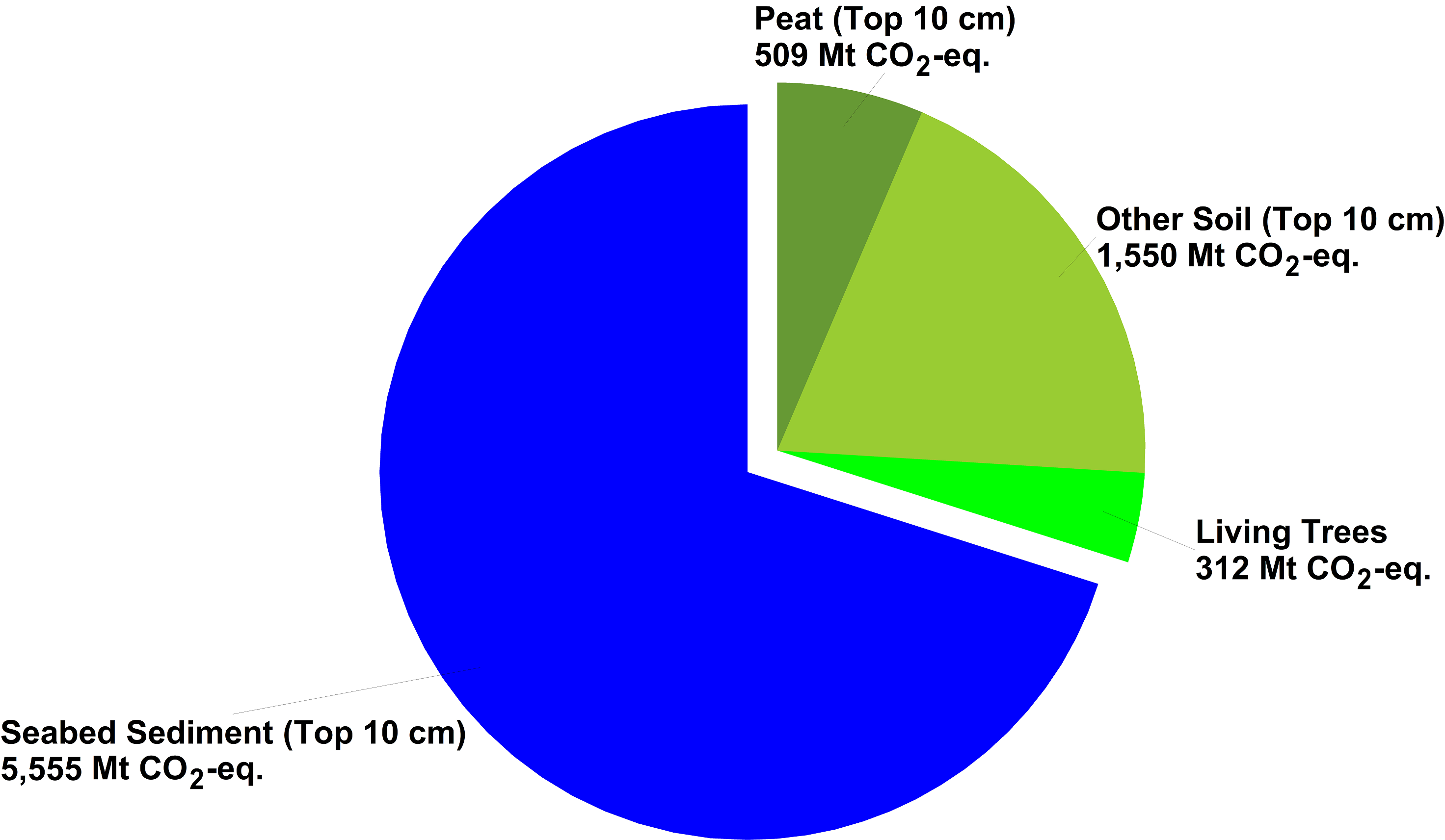
Figure 1: Schematic showing that Scottish marine sediment carbon stores (top 10 cm) presented as CO2 equivalent amounts and shown against CO2 equivalents for Scottish peatland (top 10 cm), other soils (top 10 cm) and forests (living trees) (source: https://blogs.gov.scot/marine-scotland/2020/02/24/new-blue-carbon-reports/).
A recent report (Smeaton et al., 2020) sets out to provide an improved estimate of the carbon held within Scotland’s marine sedimentary environments. Using a standardised framework, first-order estimates of Scotland’s surficial (top 10 cm) marine sedimentary carbon stock were undertaken using open-access data sources. The surficial sediments (top 10 cm) of the mapped area (554,755 km2 of the total area of 618,744 km2) of the continental shelf and Exclusive Economic Zone seabed adjacent to Scotland holds an estimated 1,515 ± 252 Mt C. Most of this carbon is in the form of calcium carbonate, with an estimated 1,294 ± 161 Mt inorganic carbon (IC) being held within the surficial sediments (Figure 2).
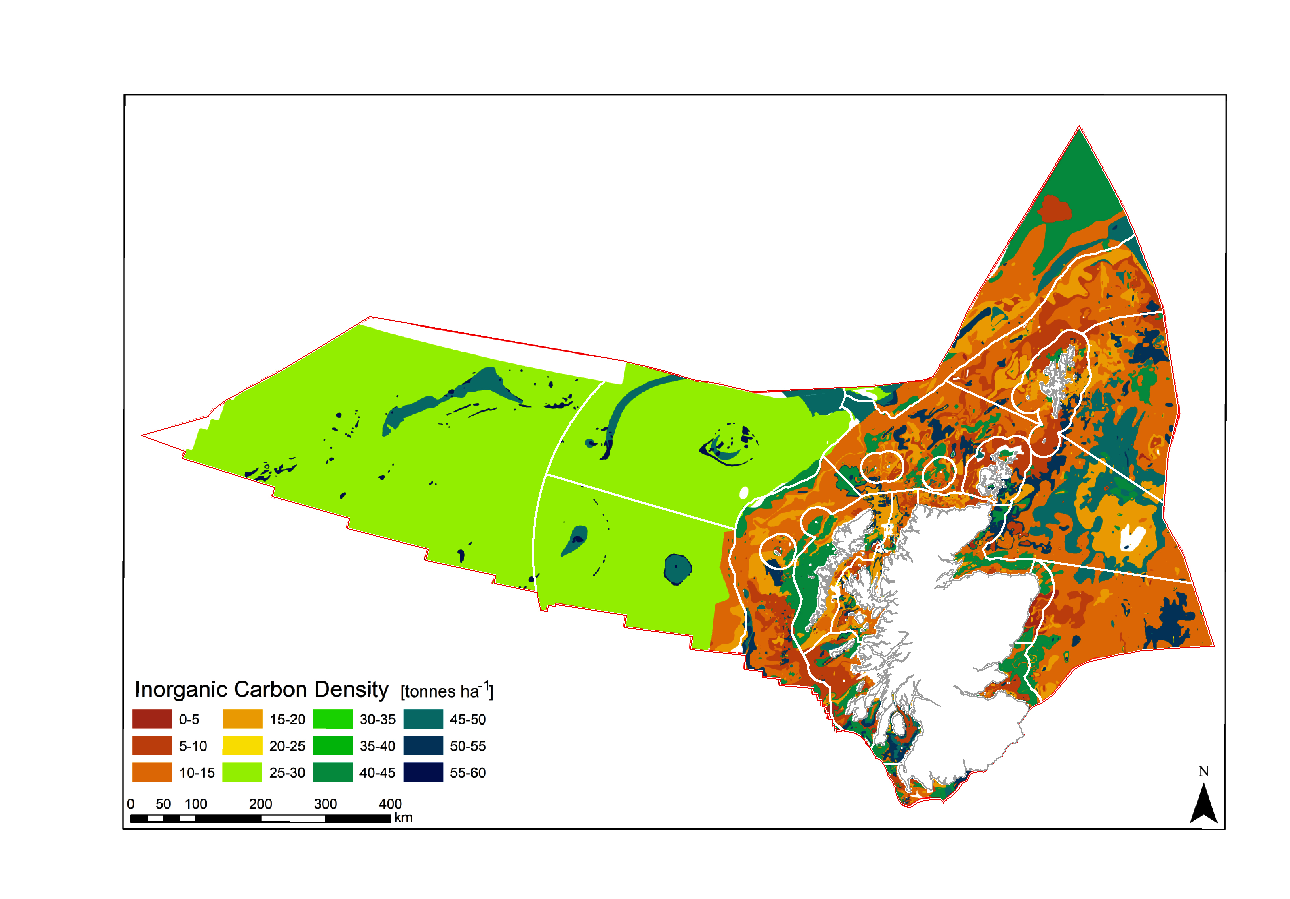
Figure 2: Spatial distribution of inorganic carbon (IC) across Scotland’s continental shelf sediments (Smeaton et al., 2020). Scottish Marine Regions and Offshore Marine Regions outlined in white.
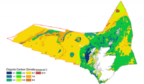
A significantly lower quantity of carbon in these surface sediments is stored in the organic (OC) form, with an estimated 221 ± 92 Mt OC currently held within the top 10 cm of sediment within the mapped area of the continental shelf and Exclusive Economic Zone (Figure 3).
Figure 3: Spatial distribution of organic carbon (OC) across Scotland’s continental shelf and Exclusive Economic Zone sediments (Smeaton et al., 2020). Scottish Marine Regions and Offshore Marine Regions outlined in white.
Scottish sedimentary carbon “hot-spots”
Significant new stores of sedimentary carbon (295.6 ± 52 Mt OC) have recently been quantified within the post-glacial sedimentary sequences of Scottish sea lochs (fjords) (Smeaton et al., 2017); it is estimated that a further 4.16 ± 0.5 Mt OC is stored in the surficial sediment (top 10 cm) of Scotland’s sea lochs (Smeaton & Austin, 2019). These organic rich sea loch sediments cover a significantly smaller area (2,052 km2) than their continental shelf counterparts, yet their carbon density (20.27 ± 3.67 tonnes OC ha-1) far exceeds that found on Scotland’s continental shelf (area < 200 m water depth) (4.2 ± 1.8 tonnes OC ha-1). These results highlight that fjords are globally significant “hot spots” for carbon burial (Smith et al., 2015) and recent work by Smeaton & Austin (2017) highlights that Scottish sea lochs provide effective traps for terrestrial carbon within coastal seas, with important implications for national carbon accounting.
|
Scotland’s mapped continental shelf area |
554,755 km2 |
|
Scotland’s unmapped continental shelf area |
40,180 km2 |
|
Surface sediments (top 10 cm) continental shelf |
1,515 ± 252 Mt C |
|
Inorganic Carbon |
1,294 ± 161 Mt C |
|
Organic Carbon |
221 ± 92 Mt C |
|
Scotland’s shelf average surface sediment OC density |
4.2 ± 1.8 tonnes OC ha-1 |
|
Scotland’s sea lochs area |
2,052 km2 |
|
Scotland’s sea lochs surface OC sediments (top 10 cm) |
4.16 ± 0.5 Mt C |
|
Scotland’s sea lochs average surface sediment OC density |
20.27 ± 3.67 tonnes OC ha-1 |
|
Global marine OC burial rates |
160 Mt C yr-1 |
Scotland has an extensive and varied coastline comprising approximately 50% rocky and 50% sedimentary intertidal habitat. Large stretches of the Mainland west coast and Northern Isles are predominantly rocky whereas on the west coast of the Outer Hebrides and the Mainland east coast it is much more patchy with rocky shores and cliffs interspersed by large stretches of sandy and muddy coastline. Intertidal habitats are affected by numerous physical variables including wave exposure, salinity, temperature and tides which dictate what animals and plants are found on specific shores. The subtidal communities are strongly affected by factors such as the availability of light, wave action, tidal stream strength and salinity. Rocky shallow continental shelf habitats are typically dominated by seaweeds and in deeper areas below the photic zone (about 50 m) communities comprise exclusively animals. Shallow subtidal sediments in places support habitats such as seagrass beds and maerl, a red seaweed with a hard chalky skeleton that forms small twig-like nodules which accumulate to form loosely interlocking beds, creating the ideal habitat for a diverse community of organisms. Typically sedimentary habitats are dominated by a range of burrowing animal species.
The Biogenic habitats assessment catalogues the loss in extent of six biogenic habitats (all Priority Marine Features): blue mussel, horse mussel, flame shell, maerl, seagrass beds, and serpulid aggregations. The Predicted extent of physical disturbance to seafloor assessment uses the degree of exposure to demersal fishing activity as a proxy for habitat condition. The Intertidal seagrass assessment is a first attempt to understand the ecological health of Scottish intertidal seagrass and is restricted to six sites.
The Case study: Biogenic habitat enhancement highlights the efforts now being made to enhance the status of some biogenic habitats through activities aimed at aiding their recovery and restoration. In other cases, where damage to Priority Marine Features has occurred, positive action is taken as demonstrated in the Case study: Protecting the Loch Carron flame shell beds where emergency measures were put in place to prevent further damage and subsequently a Marine protected Area was designated. The fact the prevention is better than cure is illustrated by the Case study: Persistent damage to the Loch Creran serpulid reefs where damage that was first observed in 1998 still shows little evidence of recovery. The value of long-term monitoring of specific sites is illustrated by the Case study: Intertidal rock which highlights how looking at changes at a community scale helps separate natural variations on species abundances from longer term community trends. The growing awareness of natural capital and ecosystem services provided by the marine environment is illustrated by the three case studies Case study: Blue carbon in Scottish maerl beds; Case study: Blue carbon in Scottish marine sedimentary environments; Case study: Blue carbon: the contribution from seaweed detritus which highlight the importance of marine habitats in climate change mitigation through the capture and storage of blue carbon, and the need for the protection of such habitats from various anthropogenic activities. Despite a long history of intertidal and subtidal survey work there remains significant gaps in knowledge. The Case study: Seabed habitats in territorial waters - the evolving knowledge-base charts the ongoing surveys that have been undertaken by government agencies and citizen science initiatives to further expand and improve the knowledge base.