
AIS - Shipping Traffic - Average weekly density of vessel types
What is it:
Maps show number of vessels using class A AIS (vessels >300grt, all passenger ships regardless of size, AIS working and not switched off, position info is accurate) and vessels carrying class B AIS (vessels <300t, fishing vessels, recreational craft). The data have been derived from a UK data set and clipped to outside Scottish waters.
AIS (Automatic Identification System) is a carriage requirement for SOLAS vesels and is an integral part of the EU Vessel Traffic Monitoring and Information Directive (2002/59/EC).
For full methodology including processing techniques and data outputs please see the MMO1066 reports.
There are 11 layers, available with time aware functionality:
- All vessel types
- Cargo vessels
- Vessels engaged in dredging or underwater operations
- Fishing vessels
- High speed craft
- Military or law enforcement vessels
- Non-port service craft
- Passenger vessels
- Port service craft
- Recreational vessels
- Tankers
Links to Scotland's Marine Atlas:
Data originators:
This information page is part of the theme:
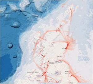
AIS sample map © Marine Scotland
Links and Resources
| Type |
Link Title |
External Link |
|---|---|---|
| Web link | MMO AIS data available on data.gov.uk | data.gov.uk |