
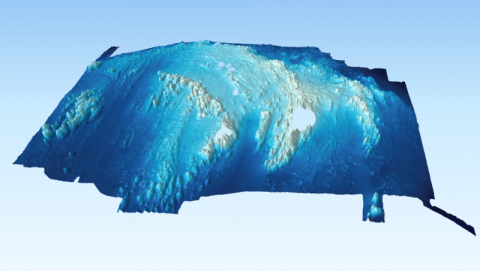
Rockall Bathymetry 2011 and 2012
In 2011 and 2012 MRV Scotia surveys 0711S and 0712S used a Reson PDS2000 multibeam echosounder to map the seabed around Rockall. Data were collected at 200 and 400 KHz frequencies at a spatial resolution of between 2 and 4 metres depending on depth. An area of approximately 6 nautical miles (north-south) by 9 nm (east-west) was mapped over the 2 surveys. The data were then merged, cleaned and processed using CARIS software HIPS and SIPS
Links and Resources
| Map Type |
Click title for metadata and licence information |
Date of data | View Map |
|---|---|---|---|
| Map Layers (NMPi) | Marine Directorate Survey Areas | 2010-07-21 | Access this map on NMPi |
| Map Layers (NMPi) | Rockall and Helen's Reef - high resolution multibeam echosounder bathymetry | 2011-06-24 to 2012-06-30 | Access this map on NMPi |