The Wider Loch Linnhe System Model
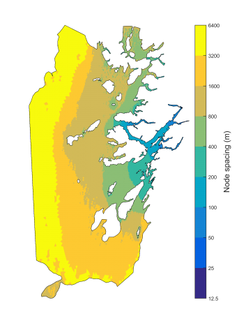
The Wider Loch Linnhe System (WLLS) model is an implementation of the Finite Volume Community Ocean Model (FVCOM) and has a domain covering many of the Inner Hebrides from the southern tip of the Mull of Kintyre to the Isle of Skye in the north. The western boundary extends to approximately 7.5° W from Northern Ireland to the southern Outer Hebrides. The model grid is unstructured with the highest horizontal resolution in Loch Linnhe, Loch Leven and Loch Sunart, where the node spacing goes down to 15 m. The typical node spacing of these sea lochs is around 50 – 100 m, with Lower Loch Linnhe having a typical node spacing of 100 – 150 m. Beyond Loch Linnhe, its side lochs, and Loch Sunart, the unstructured grid resolution reduces further, with the node spacing at the western boundary being around 5 km. The water column is resolved using a hybrid sigma layer scheme with 10 standard terrain following sigma layers, each representing 10% of the water column, in water depths shallower than 13 m. In areas deeper than 13 m. the water column is resolved with 2 fixed layers at the surface, each 1 m. thick, 2 fixed layers at the bottom, each 2.5 m. thick, and 6 sigma layers of equal spacing for the mid depths. This enables the freshwater output from Upper Loch Linnhe to be well resolved.
The main output from the model to date is a one year Climatology representing typical present day conditions (1990-2014). For this climatology, the model was forced by the wider Scottish Shelf Model (SSM) climatology at the open boundary. Effectively, the WLLS model is nested within the wider SSM. Climatological atmospheric forcing and freshwater input were also applied to the model. The wider SSM has a 1993 tidal component included, which was then applied to the WLLS climatology. The latest version of the climatology is WLLS 1.02.


