
In 2019, Marine Scotland conducted an assessment of evidence on the socio-economic impacts of Scotland’s Marine Protected Areas (MPAs) (Scottish Government, 2020 a) since management measures were introduced in 2016. The assessment used a combination of quantitative and qualitative methods to identify changes in marine industries and communities, to understand the causes of these changes, and to determine whether these changes could be attributed to MPA management measures. Four case studies were conducted to illustrate the impact of MPAs in specific geographic areas.
Background
The purpose of Nature Conservation Marine Protected Areas (NCMPAs) is to protect rare and representative species, habitats and geology across Scotland’s marine environment so that the rich diversity of life in the waters and the benefits they bring can be enjoyed in the future. Thirty NCMPAs were designated in August 2014 following two public consultation exercises in 2013 and 2014. Following this, in 2016 fisheries management measures were put in place for 10 NCMPAs, that are governed under the Marine (Scotland) Act 2010, and 9 inshore Special Areas of Conservation (SAC), that are governed under the EU Habitats Directive. It should be noted that some of these sites overlap.

|
Sites
|
Management measures
|
|
Loch Laxford SAC; Noss Head NCMPA; Wyre and Rousay Sounds NCMPA.
|
Whole site: Demersal trawl, demersal seine net, beam trawl, and dredge.
|
|
Sanday SAC; St Kilda SAC; Treshnish Isles SAC
|
Whole site: Demersal trawl, demersal seine net, beam trawl, set nets, and dredge.
|
|
East Mingulay SAC;
|
Whole site: Demersal trawl, demersal seine net, beam trawl, and dredge
Zonal management: Creel fishing, set nets, and long lines (50% of site).
|
|
Lochs Duich, Long & Alsh NCMPA/SAC
|
Whole site: Beam trawl, demersal seine net, demersal trawl, and dredge.
|
|
Luce Bay & Sands SAC
|
Whole site: Beam trawl, suction dredge, and demersal seine net, and demersal trawl.
Zonal management: Mechanical dredge permitted in Jan, Feb, Nov, Dec each year.
|
|
Loch Creran NCMPA/SAC
|
Whole site: Demersal trawl, demersal seine net, pelagic trawl, set nets, long line, beam trawl, and dredge.
Zonal management: Creel fishing.
|
|
Loch Sunart to Sound of Jura NCMPA
|
Whole site: Beam trawl, suction dredge, demersal seine net, set nets, and long lines.
Zonal management: demersal trawl without use of tickler chains, and mechanical dredge.
|
|
Loch Sunart NCMPA/SAC
|
Whole site: Demersal trawl, demersal seine net, set nets, long line, beam trawl, and dredge.
|
|
Loch Sween NCMPA
|
Whole site: Beam trawl, suction dredge, demersal seine net, demersal trawl and mechanical dredge by vessels greater than 75 gross tonnage.
Zonal management: Hand gathering, demersal trawl and mechanical dredge by vessels less than or equal to 75 gross tonnage.
|
|
South Arran NCMPA
|
Whole Site: Beam trawl, dredge, and demersal seine net, and demersal trawl by vessels greater than 120 gross tonnage.
Zonal management: Demersal trawl by vessels less than or equal to 120 gross tonnage. Creel fishing, set nets, and long lines.
|
|
Upper Loch Fyne & Loch Goil NCMPA
|
Whole site: Beam trawl, dredge, and demersal seine net, and demersal trawl by vessels greater than 75 gross tonnage.
Zonal management: demersal trawl by vessels less than or equal to 75 gross tonnage. Creel fishing, set nets, and long line.
|
|
Wester Ross NCMPA
|
Whole Site: Beam trawl, dredge, demersal seine net, and demersal trawl by vessels greater than 500 kw engine power.
Zonal management: Demersal trawl by vessels less than or equal to 500 kw engine power.
|
These management measures affect fishing activity in a number of NCMPA sites. Other marine users were already affected by the protective provisions of the Marine (Scotland) Act 2010 since NCMPA were designated in August 2014. For Special Areas of Conservation ( SACs) the provisions of Article 6 of the EU Habitats Directive have applied to other marine activities since designation. For example, designated areas need to be considered differently in planning applications for marine developments. Collectively, the two designations, NCMPAs and SACs, are considered together as Marine Protected Areas (MPAs).
The new measures affect fishing activity in a number of MPA sites and could have knock on effects for wider seafood industries as well as other marine users. Scottish Ministers have therefore committed to monitor and report on the socio-economic impact of management measures in order that appropriate actions can be taken to mitigate any severe impacts on marine users and to support emergent opportunities.
The Scottish Marine Protected Areas Socioeconomic Monitoring 2016 Report (Scottish Government, 2017) sets out the emerging evidence on the social impacts of the MPAs. This report did not find any evidence, at a national level, of significant positive or negative socio-economic impacts linked to MPA management measures introduced in February 2016. Issues and concerns were identified, nonetheless, and the report did recommend that further monitoring should be carried out over the following years. The MPA management measures had only been in place for a short period, at that time and it was felt that both positive and negative impacts might change or develop over time.
The 2019 assessment aims to provide Scottish ministers with evidence of the observed positive and negative socio-economic impacts of MPA management measures three years post implementation.
Methodology
A mixed methodological approach was used for this study to bring together both quantitative and qualitative data. This included analysis of:
- Existing quantitative fishing activity data that are held by Marine Scotland (collected for other purposes).
- Existing quantitative data on employment and compliance held by Marine Scotland.
- Qualitative data collected for the study through 100 semi-structured interviews with key informants and stakeholders in communities affected by MPAs during a period of fieldwork in September 2019.
- Survey data from questionnaires completed by the general public and local businesses in four case study areas during the fieldwork period.
- Findings from questions in the Marine Social Attitudes survey (Scottish Government, 2020 b) conducted in 2018.
Sampling approach
Key informants from the following organisations were contacted and interviewed:
- Marine Scotland Compliance
- Inshore Fisheries Groups
- Local authorities
- Tourism
- Port and harbour authorities
- Environmental NGOs
- Seafood processors
- Aquaculture
Key informants were selected from a list of individuals and organisations who had engaged with processes to designate MPA sites and to develop the MPA management measures. They were asked to provide introductions to stakeholders in the relevant area. Subsequently, a form of snowball sampling was used to identify further stakeholders. This method involved asking each stakeholder to suggest further stakeholders who might be relevant. This process continued until saturation was reached i.e. the same names came up, or time ran out.
Results
Socio-economic impacts on the fishing industry
The commercial fisheries sector is most likely to be directly impacted by MPA management measures, as a number of restrictions are placed on the type of vessel and gear that can be deployed within the MPA boundary.
Landings data showed that, in some areas, there were changes in landings after MPA management measures were introduced. Impacts were more apparent at the local level, and both positive and negative impacts were felt among different parts of the fishing industry.
An analysis of landings from trawl and dredge vessels who fished within MPA boundaries before management measures were introduced was undertaken. This suggested that trawl vessels were catching approximately 25 - 35% less from ICES (International Council for the Exploration of the Sea) rectangles1 containing MPAs. It also suggested that they were compensating for this by fishing more heavily in other rectangles, further from MPAs. Total landings for these trawl vessels remained the same, or higher, apart from the relatively small proportion of fishers who had been particularly heavy users of the fishing grounds within MPAs, whose landings reduced by approximately 12% on average. Dredge vessel landings decreased from 2013-2018, with a steeper decline post-2016. This trend was visible regardless of where they were fishing and indicated that other factors must have influenced dredge landings, but MPAs may be a contributing factor.
Interview data tended to support these findings, but offered more of an explanation of the results. Just over a quarter of fishermen (13 out of 40) reported reduced landings, as did two thirds of seafood processors (6 out of 9). This was attributed to reduced access to sheltered fishing grounds. In response, fishermen reported changing their practices in a number of ways. Many were fishing in other grounds, some had bought bigger boats to enable them to travel further and withstand harsher weather, some had diversified to creel fishing and a few had either downgraded to smaller boats or sold up. Through their adaptations, most fishermen have managed to tolerate the challenges and to continue to operate viable businesses. This may have been at some personal cost and inconvenience.
Static gear fishermen reported having greater access to the grounds within MPAs, and felt more secure fishing there without the risk of gear conflict. Some had expanded their businesses and taken on more crew.
1ICES Rectangles are areas of the sea defined by ICES (International Council for the Exploration of the Sea) that are 30 nautical miles by 30 nautical miles.
Socio-economic impacts on other key industries
Potential impacts of MPA management measures on other marine industries, namely seafood processing, aquaculture and tourism were also explored. Seafood processors tended to be affected in similar ways to fishers and were found to have adapted in similar ways. Those who had been affected were particularly concerned about their ability to retain staff.
The main impacts described by those from aquaculture were associated with the increased complexity of planning applications, which were said to be more costly and time consuming. They highlighted that delayed planning applications could lead to substantial delays to new developments and result in financial losses.
In relation to tourism, respondents felt that the MPAs had had a positive impact, as they provide an additional tourist attraction for areas nearby. Some businesses reported using the MPA designations as part of their unique selling point (USP) or their promotional material. Respondents also highlighted the importance of the natural environment for marine tourism in general. They felt that the added environmental protection afforded by MPA measures would enhance marine tourism opportunities in the future, regardless of whether those businesses used the MPA directly. An example of this is recreational fishing, which respondents hoped would expand as habitats and stocks recovered.
Wider economic and social impacts on local areas
A number of community groups and organisations had developed or galvanised around the MPAs. These groups organised a large array of activities and events with the aim of raising awareness and educating the public about marine conservation and promoting the rich diversity of their local inshore waters. They had also made links with a number of research institutions and collaborated on numerous research projects in order to gather data and improve understanding of the environmental impacts of MPAs.
Respondents mentioned seeing improvements in the marine environment, which they attributed to MPAs. For example, some reported seeing an increase in abundance and quality of shellfish and the return of species such as haddock, sandeels and sea anemones. Many stated that this was the most important positive impact of MPAs and described feelings of hope and inspiration at the thought of the improvements that were possible and what that could mean for their local area.
According to the Social Attitudes Survey, and the fieldwork questionnaires, the general public tended to be in support of MPAs, but were often unsure what they were.
Case studies
Four MPAs were chosen as case studies for this research to enable a more detailed exploration of particular issues and areas. The MPAs were chosen to ensure that a good range of types of issue were covered. Also that they illustrated how MPA management measures, and their effect on marine industries, can combine with other factors leading to significant impacts.
Selection criteria included:
- Perceptions or evidence of compliance issues in an area.
- Controversial designation of the site or concerns expressed during the consultation.
- Type of activity prohibited in the area (to get a range).
- Any evidence of changes in fishing fleet composition and/or activity.
- Any changes in port registration or landings near the MPA.
- Other marine developments nearby.
- Potential for, or existence of, tourism in the area.
- Existence of active community groups in the area.
During August and September 2019, fieldwork was undertaken in communities near the 4 MPAs. Semi-structured interviews and short surveys were carried out with stakeholders and local businesses in these communities.
South Arran MPA
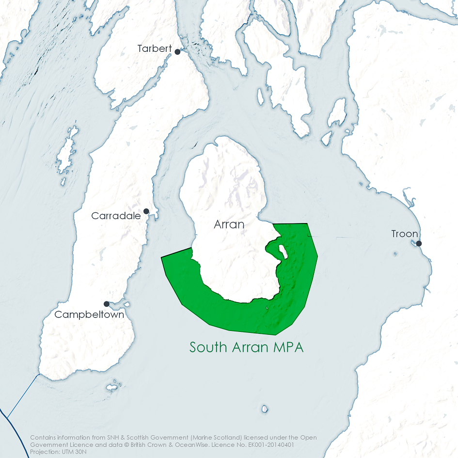
Location: Around the southern half of the Isle of Arran in the Clyde Sea. The outer boundary line is 3 miles from the coast and incorporates Holy Isle, Pladda Island and an existing No Take Zone in Lamlash Bay.
Features: Burrowed mud, kelp and seaweed communities, maerl beds, maerl or coarse shell gravel with burrowing sea cucumbers, seagrass beds, shallow tide-swept coarse sands with burrowing bivalves, ocean quahog aggregations.
Management measures - fishing methods prohibited from whole site: Beam trawl, dredge, demersal seine net, and demersal trawl by vessels greater than 120 gross tonnage.
Zonal management - fishing methods restricted to certain areas: Demersal trawl by vessels less than or equal to 120 gross tonnage, creel fishing, set nets, and long lines.
Fishers in the South Arran area reported losing access to sheltered fishing grounds, with consequences for their landings. This has had knock on effects for onshore businesses and communities. These were already suffering due to the trend of decline in fishing and the difficulties inherent with operating in a rural and remote community.
Local community groups have galvanised around the MPA, organising events and activities to raise awareness and educate people about the marine environment, and conducting research to assist with monitoring changes to the MPA. The MPA and associated opportunities are thought to provide a valuable resource for people in the wider area.
Wester Ross MPA
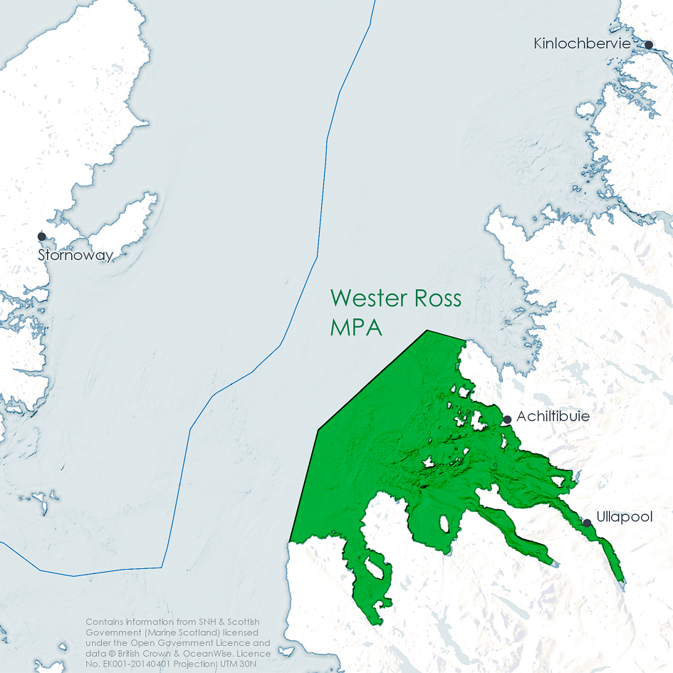
Location: Stretches from the southern part of the Coigach peninsula to Loch Ewe, encompassing the Summer Isles and extending a little into the Minch.
Features: Burrowed mud, flame shell beds, kelp and seaweed communities, maerl beds, northern feather star aggregations, circalittoral muddy sand communities, maerl or coarse shell gravel with burrowing sea cucumbers as well as geodiversity features.
Management measures - fishing methods prohibited from whole site: Beam trawl, dredge, demersal seine net, and demersal trawl by vessels greater than 500 kW engine power.
Zonal management - fishing methods restricted to certain areas: Demersal trawl by vessels less than or equal to 500 kW engine power.
Fishers from communities near the Wester Ross MPA had taken a number of steps to adapt to the management measures. This mostly involved changing their fishing patterns to fish in different areas. Unrestricted fishing grounds are becoming fairly crowded, and there were concerns about the impact the increased fishing pressure might have on those fishing grounds. On the other hand, respondents reported improvements to stocks and habitats within the MPA boundary.
Loch Sunart to the Sound of Jura MPA (includes Firth of Lorn SAC, Loch Sunart SAC and Loch Sunart NCMPA)
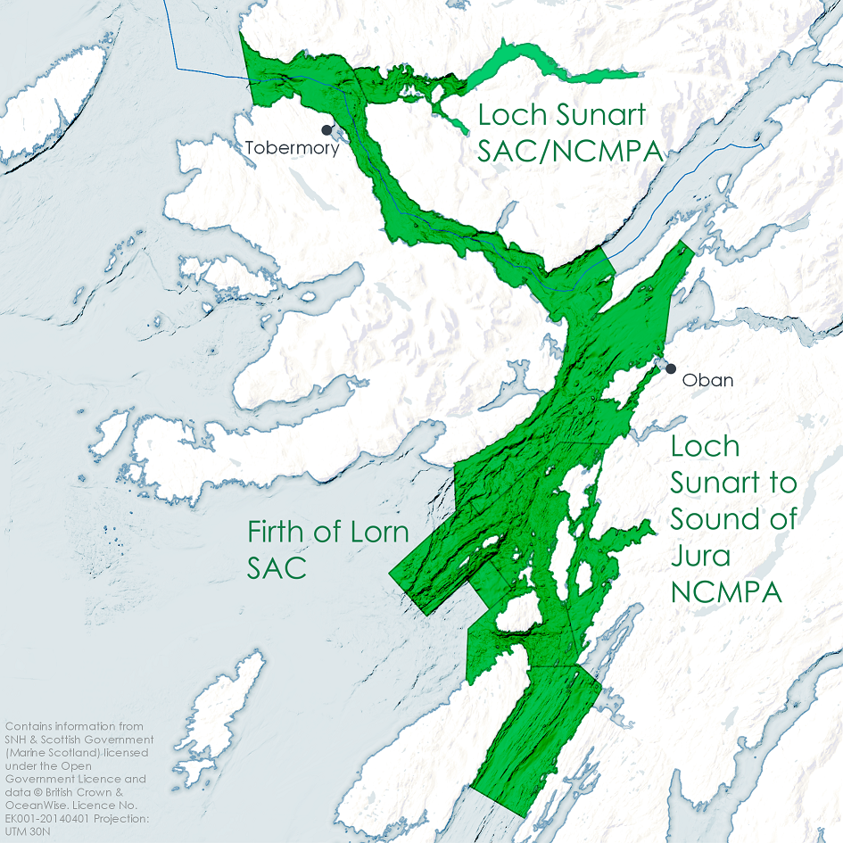
Location: Extends northwards from the Sound of Jura, covering the Firth of Lorn and the south-western part of Loch Linnhe also through the Sound of Mull and into Loch Sunart.
Features: Common skate as well as geodiversity features.
Management measures - fishing methods prohibited from whole site: Beam trawl, suction dredge, demersal seine net, set nets, and long lines.
Zonal management - fishing methods restricted to certain areas: demersal trawl without use of tickler chains, and mechanical dredge.
Displacement was an important impact for fishers near the Loch Sunart to Sound of Jura MPA, with some fishers describing having to travel over 3 hours before reaching grounds in which they could fish. Some adapted by changing their fishing patterns so that they would stay out on the boat and fish for 3 days, before coming home. Others upgraded to bigger boats which could travel further, shifting to a more nomadic style of fishing.
Wildlife tourism was thought to be very important for the local area, and an industry that was growing. Respondents highlighted that a healthy marine environment with thriving populations of marine flora and fauna was important for this sort of tourism to work.
Orkney case study (Wyre and Rousay Sounds NCMPA and Sanday SAC)
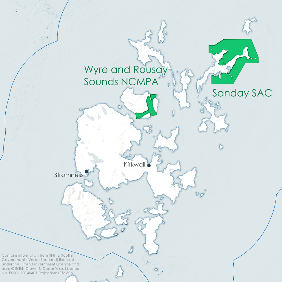
Location: Covers the sounds between the islands of Rousay, Wyre and Egilsay in Orkney, north Scotland. The area covers channels swept by the tides of the Atlantic and the North Sea supporting large beds of maerl and kelp and seaweed communities. Sanday SAC surrounds most of northeast Sanday Island, from Backaskaill Bay round to the Holms of Ire.
Features: Wyre and Rousay Sounds NCMPA: Kelp and seaweed communities on sublittoral sediment, maerl beds, as well as geodiversity features. Sanday SAC: harbour seals, reefs, subtidal sandbanks, intertidal mudflats and sandflats.
Management measures - fishing methods prohibited from whole site: Demersal trawl, demersal seine net, beam trawl, and dredge.
Other context: Most activity in the area is from under 15 m creel and dive vessels. Three finfish farms are located within the boundary of the MPA. The Fall of Warness (European Marine Energy Centre (EMEC), up to 4 MW capacity) tidal energy generation test site is within 5 km of the MPA boundary while the Westray South (SSE Renewables Developments (UK) Limited, 200 MW capacity) tidal energy generation development is in development.
Respondents from communities near the Orkney MPAs (Kirkwall and Stromness) did not describe significant impacts due to the MPAs. There are a number of industries operating in the waters around Orkney, and the challenge here is navigating the impacts these industries might have on each other. While these industries provide employment, and so reduce the reliance on fishing, there are also concerns that some of these industries are taking potential crew away from the fishing industry. These issues were of greater concern among respondents than the existence of the MPAs.
Conclusions
This research has drawn on a wide range of sources of evidence, both quantitative and qualitative, and perhaps most importantly has included detailed input through interviews with individuals from a range of impacted industries in different localities. It is challenging to draw clear conclusions on the extent of impacts that MPAs have had, but using a combination of methods and data sources enables some confidence to be drawn in the findings.
There is certainly evidence that MPAs have made fishing more challenging in some areas, with knock on impacts for associated industries, and these businesses have had to adapt to survive. There are also positive environmental and community impacts, particularly with regard to environmental awareness, research and education.
The clearest message from the research, however, is that MPAs are one of many challenges that face marine industries and their communities. Where impacts were felt, this was often due to a combination of factors, one of which was the MPAs. Whilst in some cases MPAs may have a minimal direct impact, when evaluated in combination with other existing challenges, they can exert a greater strain than might be immediately apparent.
The seas around Scotland are home to a wide variety of animals and plants and are of international importance as a stronghold for many species. Whilst the protection of the wider environment through the management of various activities is essential, Marine Protected Areas (MPAs) have an equally important role to play in the protection and conservation of key habitats and species. There are now 230 MPAs covering 37% of Scotland’s marine environment (at December 2020, it was 22% in 2018 at the end of the assessment period) comprising MPAs for nature conservation (Nature Conservation MPAs; Special Areas of Conservation (SACs); Special Protection Areas (SPAs); Sites of Special Scientific Interest (SSSIs); and Ramsar sites), MPAs for other purposes (Demonstration and Research MPAs; and Historic MPAs), and Other Area-based Measures. Work continues to implement all the necessary management measures and the on-going monitoring necessary to determine the effectiveness of the protection afforded by the MPAs. The Case study: Protecting the Loch Carron flame shell beds documents the emergency measures put in place to prevent further damage after scallop dredgers destroyed part of the bed. In other cases, it is apparent that prevention is better than cure – the Case study: Persistent damage to the Loch Creran serpulid reefs where damage first recorded in 1998 still shows little evidence of recovery. The Case study: Flapper skate – Loch Sunart to the Sound of Jura MPA describes how the on-going monitoring involving recreational anglers has not only improved our understanding of the ecology but also the information necessary for determining the management measures needed to ensure their protection.
Perhaps one of the greatest challenges is balancing the need for protection and therefore control of certain activities with the resulting possible socio-economic impacts. The Case study: Socio-economic impacts of marine protected areas describes the outcomes of an initial assessment of the evidence and views of the impact of MPA designation. These are some initial findings from only 2-3 years after designation and whilst there is evidence in some areas that fishing has been made more challenging there are also early signs of positive environmental and community impacts. The lessons from other parts of the world is that to get a full and balanced picture of the effects of MPA designation takes time.
Scotland’s vision for the seas is that they are economically productive and that marine industries are sustainable. The assessment of productivity is mainly based on a new annual Scottish Government publication Scottish Marine Economic Statistics. The assessment is presented through four activity Themes: Living resources - Aquaculture, Fishing, Fish processing, Seaweed harvesting and cultivation, Salmon and sea trout fishing; Energy & mineral resources - Renewable energy, Oil and gas sector and infrastructure, Water abstraction, Carbon capture utilisation & storage, Aggregates; Transport, communication, defence and waste - Maritime transport (freight, ports and shipping), Maritime transport (passengers, ferries and cruise ships), Waste disposal - dredge material, Military activity, Coastal erosion and flood risk management, Subsea cables, Waste water treatment and industrial outfalls; and Recreation and cultural heritage - Marine tourism, Historic environment and cultural heritage. Case Studies on particular topics are also presented under each Theme as well as case studies on Scotland's coastal town typology, Socio-economic impacts of marine protected areas; and an Overview of the marine economy. In October 2020 Scotland's marine economic statistics 2018, which includes economic data up to 2018, was published but it was not possible to incorporate these into SMA2020.
The Productive assessment in Scotland’s Marine Atlas 2011 can be found on the Scottish Government web archive here.
Themes

Links and resources
|
, 2020. Attitudes in Scotland on the marine environment and marine issues, Edinburgh: Scottish Government. Available at: https://www.gov.scot/publications/attitudes-scotland-marine-environment-marine-issues/. |
|
, 2017. Scottish Marine Protected Areas socioeconomic monitoring 2016 report, The Scottish Government. Available at: https://www.gov.scot/publications/scottish-marine-protected-areas-socioeconomic-monitoring/. |
|
, 2020. Monitoring the socio-economic impacts of Marine Protected Areas: report, The Scottish Government. Available at: https://www.gov.scot/publications/monitoring-socio-economic-impacts-marine-protected-areas/. |