Scotland's Marine Assessment 2020

Welcome to the Scotland’s Marine Assessment 2020 (SMA2020) portal which reports on the vision for the seas
‘clean, healthy, safe, productive, biologically diverse marine and coastal environments, managed to meet the long-term needs of nature and people’.
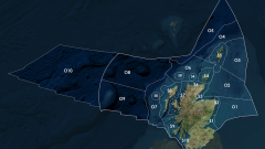
Scotland’s seas, an area within the Exclusive Economic Zone (EEZ) covering approximately 462,000 km2 have economic activity worth £5.1 billion (Gross Value Added (GVA)) to the Scottish economy excluding oil and gas extraction and £14.7 billion including oil and gas.
By delivering an assessment of both the state of Scotland’s seas and of the main activities and pressures in the various Scottish Marine Regions and Offshore Marine Regions, SMA2020 fulfils the requirement of the Marine (Scotland) Act 2010 which requires that, prior to reviewing the National Marine Plan, an assessment of the state of Scotland’s seas is undertaken. SMA2020 presents, where possible, trends for the period 2014 to 2018 with longer term data presented where this sets the 2014 to 2018 period in a longer term context. Economic trends for GVA, the value of goods and services produced minus the cost of raw materials and other inputs used to produce them, are for 2013 to 2017. This includes the latest published data at the time of writing SMA2020. In October 2020 Scotland's marine economic statistics 2018, which includes economic data up to 2018, was published but it was not possible to incorporate these into SMA2020. Similarly, the Marine Protected Area assessment does not take into account the designation of MPAs since the end of 2018, for example the West of Scotland MPA and others designated in 2020.
The SMA2020 portal is structured around the vision for the seas, with sections on, for example, clean and safe. In addition, there are separate sections on a number of topics including climate change and pressures from activities as set out on the tiles below. In all there are 183 components to SMA2020.
The majority of spatial data used in the assessments are available through the Marine Scotland Open Data Network (MS Data, MS Information, MS Maps NMPi) or other online portals. This provides transparency to the process which is critical in engendering confidence in the conclusions.
This assessment has been prepared over the last few years with peer review undertaken in 2019 and 2020. By its nature it does not take into account any effects of the COVID-19 pandemic.
SMA2020 should be cited as: Colin Moffat, John Baxter, Barbara Berx, Kirsty Bosley, Philip Boulcott, Martyn Cox, Lyndsay Cruickshank, Katie Gillham, Adam Cox, Venetia Haynes, Ashley Roberts, David Vaughan, & Lynda Webster (Eds.). (2020). Scotland's Marine Assessment 2020. Scottish Government.
This peer reviewed assessment has been delivered by a partnership of organisations from across the Scottish marine community including:

A full list of the contents of the 183 components, with links to the relevant Themes, Assessments and Case Studies, can be found in the Introduction under What is assessed.