Background
Seawater clarity is often assessed based on the concentration of suspended particles in the water column, also called turbidity. This suspended particulate material (SPM) includes mineral particles, as well as living and dead plankton. Here, suspended particulate inorganic matter (SPIM), measured by ocean colour satellites from space, is used to summarise the turbidity in Scottish waters.
Increased turbidity of marine waters has the potential to impact the productivity of photosynthetic marine organisms, by reducing the amount of light that passes through the water column. However, suspended particles may also increase the nutrient concentrations and therefore positively affecting primary producers.
SPIM can be brought from land to sea by freshwater outflows (river or sewage discharge), and can also be re-suspended from the sea bed into the water column by turbulent mixing (from tidal currents and wind). SPIM can also be affected by activities on the sea bed e.g. dredging, trawling and marine construction. Due to these processes, shallow, coastal waters generally have higher SPIM concentrations than deep, offshore regions.
Satellite ocean colour measurements allow for the observation of SPIM on a large spatial scale, but often include some degree of temporal averaging and interpolation to deal with cloud cover. Moreover, algorithms to derive SPIM concentration from satellites are often developed for specific regions and may not yield accurate results in other regions.
The assessment of turbidity was undertaken by Marine Scotland Science, based on data compiled by CEFAS (Centre for Environment, Fisheries and Aquaculture Science) for the Marine Online Assessment Tool.
The assessment of turbidity in Scottish waters was based on satellite observations of SPIM. Overall, these data are sufficient for an overall descriptive state of SPIM in Scottish waters. However there is not enough confidence to investigate trends without further in situ observations of suspended sediments and optical properties in Scottish waters to validate the satellite observations and the algorithms applied.
Data were provided by Silva (2016). These are daily estimates generated by IFREMER (Institut Français de Recherche pour l'Exploitation de la Mer) from multiple ocean colour remote sensing platforms (SeaWifs, MODISv, MERIS, VIIRS) and interpolated to a 1.1 x 1.1 km grid. These estimates were further averaged to create monthly/annual averages and averages for the period 1998 - 2015. Detailed methods for data analysis can be found in CEFAS Report (2016).
Ocean colour satellite sensors measure sunlight being backscattered by the water and its constituents (dissolved coloured matter and particles). To convert this colour to meaningful quantities (such as chlorophyll a or suspended sediments), a number of algorithms have been developed. These can be sensitive to the initial region for which they were established, creating uncertainties in the data.
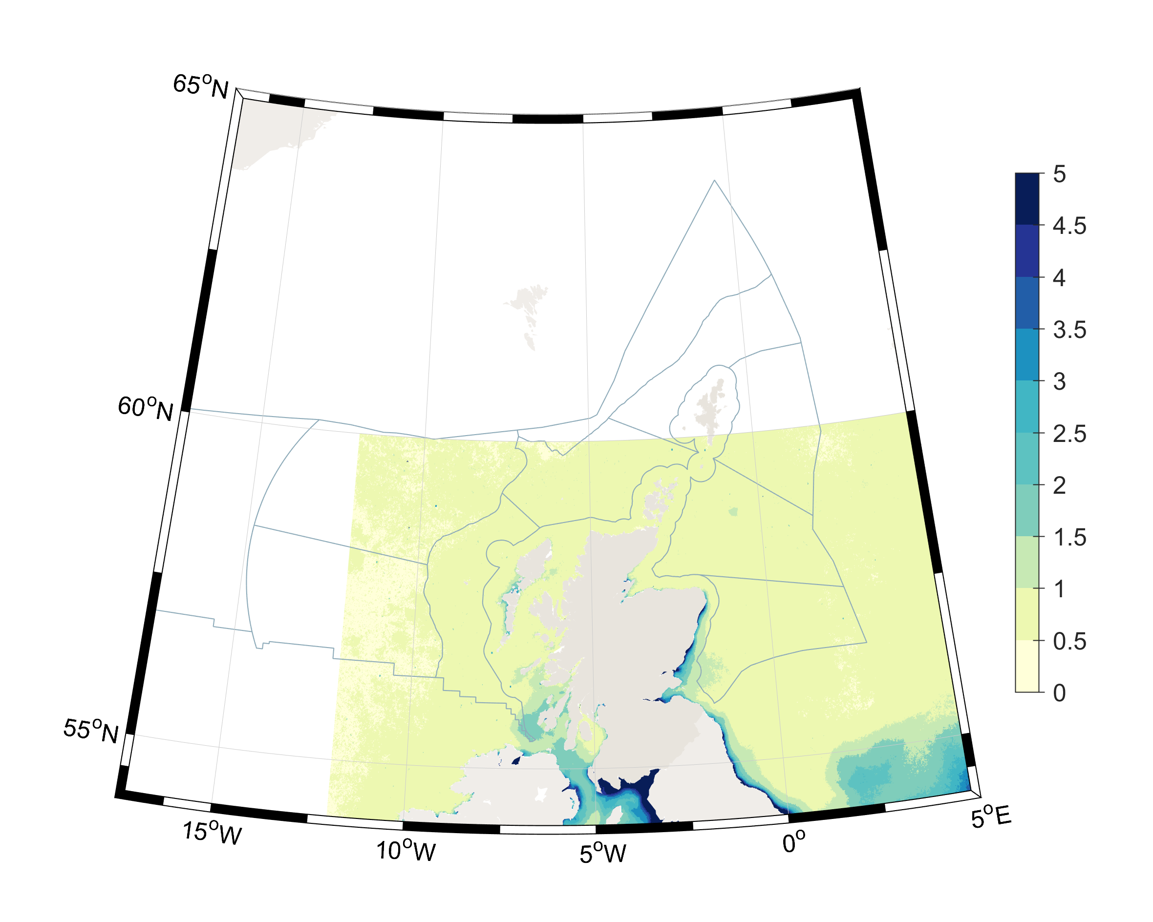
The data do not cover all of Scottish waters, and extend from 54° N to 57° N and from 12° W to 5° E, due to satellite measurement constraints. The following Offshore Marine Regions (OMRs) and Scottish Marine Regions (SMRs) are only partially represented: Bailey, Rockall, Faroe-Shetland Channel, North Scotland Shelf, North and West Shetland Shelf, East Shetland Shelf and Shetland, so additional care should be taken in interpreting data in the regions. There are no data for the Hatton OMR. Winter sun angle, weather conditions and cloud cover all affect the collection of ocean colour data north of 57° N.
Results
The 1998-2015 climatological average shows there is a marked difference in SPIM concentration between the north/south and coastal/offshore regions within Scottish waters (Figure 1). Turbidity is highest in the coastal areas with high freshwater input i.e. Solway Firth, Clyde, Argyll and Forth & Tay river plume. The more northerly coastal regions have lower SPIM loads than the southerly regions. The offshore regions have lower SPIM than the coastal regions. Compared to the southern North Sea, the northern North Sea has much lower concentrations of SPIM.

Offshore marine regions
Overall the monthly average of SPIM in the OMRs is <1.5 mg/l year round. All regions appear to increase in SPIM in the summer months, highest in June (Figure 2). A winter peak in SPIM is most pronounced in the Long Forties region from 2006 onwards. However, high SPIM in the summer months may be an artefact of the method and algorithm used to estimate SPIM from ocean colour data.
It is not appropriate to assess trends using this data set, due to the poor spatial coverage of some regions. Data for December are missing for 7 out of 10 regions from 2007 onwards (most likely due to cloudiness and winter sun angle reducing observations).

Scottish marine regions
In general, SPIM concentrations in the SMRs are higher than in the OMRs (note the colour bar change in Figure 2 and Figure 3). This is due to their general shallower bathymetry and closer proximity to sources of land run-off. The Solway Firth has by far the highest SPIM concentrations, on average between 4 and 6 mg/l (Figure 3) but greater than 20 mg/l during isolated events (potentially linked to high river run off). The high SPIM concentrations in the Solway can last for several months at a time.
Relatively high SPIM concentrations (>3mg/l) occur in the Forth and Tay, Clyde, Argyll and North East regions. These concentrations are on average not as high as those in the Solway, and the duration of high concentrations is also not as long as for the Solway. Highest SPIM occurs in the winter months as more river run off means more sediments are washed down to the sea. Also, stronger winds and waves and storm events act to re-suspend sediment from the shallow coastal waters. There are missing data for northerly coastal regions in December 2007 onwards.
The high SPIM concentrations in the Solway and Forth and Tay (and to a lesser extent North East) regions are most likely due to the large estuaries in these regions.

No trend assessment has been included due to insufficient data and the need for more in situ observations to validate the satellite data. Ocean colour measurements and algorithms are continuously improving, but often rely on detailed measurements of water optical properties and suspended sediment concentration.
No comparison has been made to the 2011 data. The previous marine assessment (Baxter et al., 2011) displayed turbidity data from a numerical model.
Here, an improvement has been made on the previous assessment method by using a validated and quality assured observational data set. However, the algorithms used to derive SPIM from ocean colour remote sensing images are complex, and sensitive to the regions where they were initially developed for. More work on remote sensing of suspended matter in Scottish waters is needed to improve confidence in these data, and allow for the analysis of trends.
Large gaps in knowledge exist due to limitations of ocean colour satellite data.
Conclusion
The highest SPIM concentrations occur in the coastal regions with high river influx and during the winter months.
In general, most regions have low SPIM concentrations (<3mg/l) on average.
Due to the nature of the observations there is limited confidence in offshore regions, although these are also where SPIM concentrations are lowest.
Knowledge gaps
Three main knowledge gaps have been identified:
- lack of ground-truthing of data in Scottish waters for ocean colour algorithm;
- lack of data for offshore marine regions, particularly in the winter months;
- restricted spatial extent of current data set – limited conclusions can be drawn particularly for Hatton, Faroe-Shetland Channel, North & West Shetland Shelf, Shetland and East Shetland Shelf.


