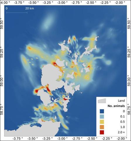
Fine-scale harbour seal at-sea usage mapping around Orkney and the North coast of Scotland
Marine Scotland commissioned the Sea Mammal Research Unit (SMRU) at the University of St Andrews to produce fine-scale at-sea usage maps showing the distribution of harbour seals around Orkney and north coast of Scotland.
These ‘usage’ maps are produced by looking at movement data from telemetry tagged seals between 2003 and 2015. The resulting patterns of usage are scaled to population levels using data collected in aerial survey counts at haul-out sites, to produce estimates of mean density at a spatial resolution of 0.6 km x 0.6 km grid cells.
This report describes how fine-scale harbour seal usage maps around Orkney and the north coast of Scotland can be used and interpreted, as well as the caveats and limitations, and methodology used to produce them. As such it should be regarded as essential reading before the maps are used.
For questions relating to the use of the maps or their interpretation please contact marinescotland@gov.scot
The maps described above are available to download from the links in the table below. They are available in shapefile and geotiff formats.
Links and Resources
| Map Type |
Click title for metadata and licence information |
Date of data | View Map |
|---|---|---|---|
| Map Layers (NMPi) | Common/harbour seal (Phoca vitulina) - Orkney and North Coast - fine-scale at sea usage map | 2003-01-01 to 2015-12-31 | Access this map on NMPi |


